


ADAMS 2, Parke County, Indiana
About
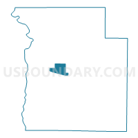
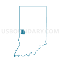
Outline

Summary
| Unique Area Identifier | 580004 |
| Name | ADAMS 2 |
| County | Parke County |
| State | Indiana |
| Area (square miles) | 4.90 |
| Land Area (square miles) | 4.89 |
| Water Area (square miles) | 0.00 |
| % of Land Area | 99.93 |
| % of Water Area | 0.07 |
| Latitude of the Internal Point | 39.77648760 |
| Longtitude of the Internal Point | -87.26425220 |
Maps

Graphs
Select a template below for downloading or customizing gragh for ADAMS 2, Parke County, Indiana


Neighbors
Neighoring Voting District (by Name) Neighboring Voting District on the Map
- ADAMS 1, Parke County, IN
- ADAMS 3, Parke County, IN
- ADAMS 4, Parke County, IN
- PENN, Parke County, IN
- RESERVE, Parke County, IN
- WABASH, Parke County, IN
- WASHINGTON, Parke County, IN
Top 10 Neighboring County Subdivision (by Population) Neighboring County Subdivision on the Map
- Adams township, Parke County, IN (5,825)
- Reserve township, Parke County, IN (1,423)
- Washington township, Parke County, IN (1,302)
- Wabash township, Parke County, IN (818)
- Penn township, Parke County, IN (810)
Top 10 Neighboring Place (by Population) Neighboring Place on the Map
Top 10 Neighboring Unified School District (by Population) Neighboring Unified School District on the Map
- Rockville Community Schools, IN (7,387)
- Southwest Parke Community School Corporation, IN (5,278)
- Turkey Run Community School Corporation, IN (3,937)
Top 10 Neighboring State Legislative District Lower Chamber (by Population) Neighboring State Legislative District Lower Chamber on the Map
- State House District 41, IN (68,641)
- State House District 44, IN (62,916)
- State House District 42, IN (58,863)